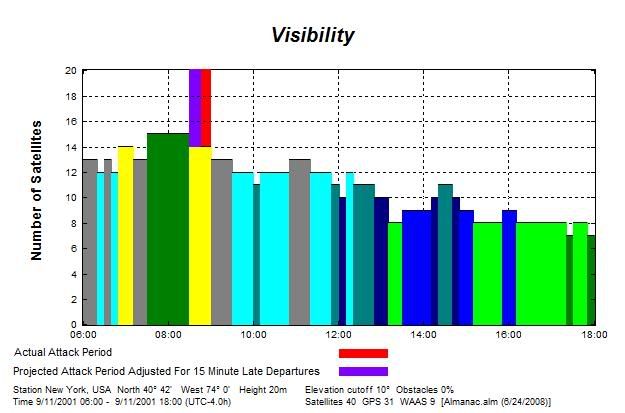
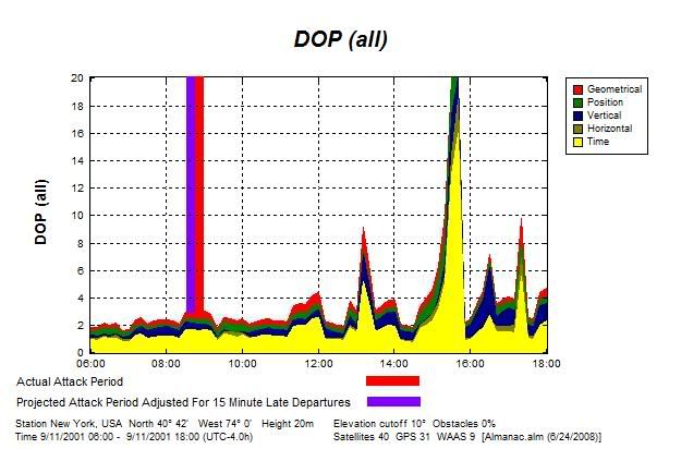
As the aircraft attacks of September 11, 2001 unfolded at the World Trade Center, virtually maximum augmented GPS positioning quality for the entire daylight period was provided to the geographic coordinates for the World Trade Center.
GPS position quality is strongly affected by the number of GPS satellites visible to a GPS receiver and the orbital geometry of GPS satellites with respect to a GPS receiver. Augmented GPS signal receivers and Flight Management Systems that utilize augmented GPS signals for navigation and positioning purposes were scheduled to be contained by American and United airlines Boeing 757s and 767s by 2000.
"Factors that can degrade the GPS signal and thus affect accuracy include the following: Number of satellites visible - The more satellites a GPS receiver can "see," the better the accuracy; Satellite geometry/shading - This refers to the relative position of the satellites at any given time. Ideal satellite geometry exists when the satellites are located at wide angles relative to each other. Poor geometry results when the satellites are located in a line or in a tight grouping."[1]

The period of fourteen-fifteen visible GPS/WAAS satellites from the coordinates of the WTC (40° 42′ 42″ N, 74° 0′ 45″ W) occupied only 14.5% of the hours between sunrise and sunset on September 11, 2001. It was during this brief period of virtually maximum GPS/WAAS satellite visibility from the WTC that the aircraft attacks at the WTC unfolded.
"Dilution of precision (DOP) or geometric dilution of precision (GDOP) is a GPS term used in geomatics engineering to describe the geometric strength of satellite configuration on GPS accuracy. DOP Value Rating Description:1: Ideal This is the highest possible confidence level to be used for applications demanding the highest possible precision at all times. 1-2: Excellent At this confidence level, positional measurements are considered accurate enough to meet all but the most sensitive applications. 2-5: Good Represents a level that marks the minimum appropriate for making business decisions. Positional measurements could be used to make reliable in-route navigation suggestions to the user. 5-10: Moderate Positional measurements could be used for calculations, but the fix quality could still be improved. A more open view of the sky is recommended. 10-20: Fair Represents a low confidence level. Positional measurements should be discarded or used only to indicate a very rough estimate of the current location. >20: Poor At this level, measurements are inaccurate by as much as 300 meters with a 6 meter accurate device (50 DOP × 6 meters) and should be discarded."[2]

The position component (green band) for measured dilution of precision for WTC coordinates during the impacts of American Airlines flight 11 and United Airlines flight 175 is valued at approximately 2.5.

Source: Trimble's Planning Software [3]
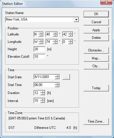
Coordinates for the World Trade Center: 40° 42′ 42″ N, 74° 0′ 45″ W
http://en.wikipedia.org/wiki/World_Trade_Center Enhanced GPS service (WAAS) now in use by the U.S. commercial aviation industry and activated 13 months prior to the terrorist attacks of September 11, 2001, provided virtual aerial navigation corridors only 243 wide and a 95% confidence that an aircraft's true position will fall within such a corridor. Such corridors can be navigated entirely by autopilot and flight management systems scheduled in 1996 and 1998 to be contained by United and American airlines Boeing 757 and 767 aircraft like those used during the terrorist attacks of September 11, 2001.

http://www.flightglobal.com/articles/2003/01/07/159964/ups-wins-faa-cert...
http://www.boeing.com/commercial/caft/reference/documents/RNP757767.pdf 1 nautical mile = 6,076 feet
RNP 0.02 = RNP (0.02 nautical mile radius) x 2 = RNP (121.5 foot radius) x 2 = a 243 foot wide corridor.

August 24, 2000
WASHINGTON, DC — After a successful 21-day stability test of the Wide Area Augmentation System (WAAS) signal in space, the U.S. Department of Transportation's Federal Aviation Administration (FAA) declared that it is now available.
http://www.faa.gov/news/press_releases/news_story.cfm?newsId=5249 According to Raytheon’s director-satellite navigation systems, the newly activated WAAS signal was used by rescuers at New York City's Ground Zero site following September 11, 2001 in order to precisely survey the site:
http://www.aviationtoday.com/av/categories/commercial/12571.html By 1996 and 1998, United and American airlines Boeing 757 and 767 aircraft, like those used during the terrorist attacks of September 11, 2001, were scheduled to contain flight management systems and signal receivers capable of utilizing the new GPS service.
FARNBOROUGH, ENGLAND, SEPT. 7, 1998 - The Honeywell "Pegasus" flight management system earned its first FAA certifications March on the Boeing 757, 767 and MD-90 aircraft types ... Airlines get FANS-1/FANS-A capability ... FANS-1 ... allows operators to obtain more economical routings and to utilize satellite navigation.
http://www.aviationnow.com/shownews/farnday1/pressr15.htm
http://www51.honeywell.com/aero/common/documents/Go_Direct_Downloads_for...
http://satjournal.tcom.ohiou.edu/issue9/aviation_navigation.html
CEDAR RAPIDS, Iowa, Sept. 6, 1996 /PRNewswire/ -- Rockwell's Collins Commercial Avionics, based in Cedar Rapids, has made major announcements of the selection of its Multi-Mode Receiver (MMR) landing system by two of the world's leading aircraft manufacturers, Airbus and Boeing ... Subsequent certifications are planned for Boeing's ... 757 and 767 ... The Multi-Mode Receiver ... expands capabilities required by the air transport industry as the Global Navigation Satellite System (GNSS) is phased into operation.
http://www.highbeam.com/doc/1G1-18652301.html
http://en.wikipedia.org/wiki/Global_navigation_satellite_system The WAAS signal also made possible under autopilot control, the 370 degree decending right turn from an altitude of 7,000 feet, performed by American Airlines flight 77 prior to its reported impact with the Pentagon building in Arlington, VA on September 11, 2001.
Stanford University, 1998:
http://waas.stanford.edu/~wwu/jennings/publications/ION98/iongps98.pdf 

Boeing 757s and 767s containing such Flight Management Computers and Multi-mode Receivers, can precisely self-navigate entirely under augmented GPS-guided autopilot control, to destinations still out of sight and along routes that reportedly never vary more than 18 meters.
"Guided entirely by autopilot, an Air China Boeing 757 jet last month snaked along a narrow river valley between towering Himalayan peaks ... the airplane automatically followed the twists of the valley, descending on a precisely plotted highway in the sky toward a runway still out of sight ... Using global-positioning satellites and on-board instruments, Naverus' navigation technology pinpoints the location of a fast-moving jet to within yards ... "You're watching the whole thing unfold. The airplane is turning, going where it's supposed to go ... it's all automatic.""[4]
"For this RNP approach in Tibet, an Air China Boeing 757 was relying on dual GPS receivers, flight path computers and inertial reference systems ... the aircraft we are on is equipped with Honeywell Pegasus flight management systems and Rockwell Collins multi-mode receivers."[5]
The capability to remotely transmit altered aircraft flight plan data via remote data link transmissions directly into Boeing 757 and 767 aircraft Flight Management Computers (FMCs) for use by aircraft auto-pilot functions, was technologically available circa 2001.
Developed in 1999 and technologically supported by the FANS-capable (Future Air Navigation System) Honeywell Pegasus Flight Management System (FMS) for Boeing 757s and 767s by 2000, Dynamic Airborne Reroute Procedure (DARP) technology enables aircraft course changes via modified flight plan waypoints remotely transmitted and installed into aircraft FMCs by VHF or SATCOM (satellite communications) transmission uplinks.
"Dynamic Rerouting, meaning the ability of controllers ... to change a filed routing once the flight is in progress ... "The new flight plan with all new waypoints goes into the data link to the comm satellite and is then downlinked into the FMSes of the individual aircraft," ... "And 'Wow,' say all the old pilots, 'Untouched by human hands!'" ... Our [dispatch] computer uplinks a route into the FMS that is identified as 'Route 2.' [You're already flying 'Route 1.']" [6]
A January, 2002 description of the capabilities of the Pegasus Flight Management System (FMS) for Boeing 757s and 767s:
""AOC (airline operations center) data link is an optional feature of the Pegasus FMC. This feature provides data link communication of ... route modifications ... directly into the FMC (flight management computer)."[7]
A May, 2000, explanation of the capabilities of the Pegasus Flight Management System (FMS) for Boeing 757s and 767s:
"A route request may either be a route modified by the crew, or a route which has been sent to the airplane from the Airline Data System."[8]
"The route can be sent by airline operations directly to the ATC Facility via AIDC, for example, for review and uplink to the aircraft."[9]
"At the time of the airworthiness approval of the 757/767 (Pegasus ‘00) FANS 1 FMC, the operational requirements ... for providing ... Dynamic Airborne Route Planning (DARP) based on FANS 1 communication capability were not determined."[10]
June, 2001:
"Dynamic rerouting (DARP) is not fully operational - Technology is available."[11]
The May, 2000, description of the capabilities of the Pegasus Flight Management System (FMS) for Boeing 757s and 767s continues:
"Three independent VHF systems (radios and antennas) are installed on the airplane to provide line of sight voice and data communication."[12]
"Satellite communications (SATCOM) may be provided for remote communications where terrestrial contact is unavailable, or by airline policy regardless of the state of other communication capabilities."[13]

The May, 2000, description of the capabilities of the Pegasus Flight Management System (FMS) for Boeing 757s and 767s continues:
"The FMC has the capability to store 2 routes, designated as route 1 and route 2. The route which defines the flight plan along which the airplane is to be flown is the active route."[14]
A Federal Aviation Administration publication description of the capability to remotely modify active flight plans already being executed by certain aircraft Flight Management Systems:
"Planned Airborne Re-route Procedure – DARP (Data link Aircraft): AOC (airline operations center) will plan the re-route and uplink the route to the aircraft, commencing from the waypoint on the current route, ahead of the Aircraft and finishing at destination. Note: Some Flight Management Systems allow AOC uplinks to the Active Route. It is recommended that all AOC route uplinks are directed to the Inactive Route."[15]


"Trimble is a leading provider of advanced positioning solutions that maximize productivity and enhance profitability. Trimble products are used in over 100 countries around the world. For over 30 years, Trimble has created unique positioning products that help customers grow their business. Our portfolio includes over 850 patents and serves as the basis for the broadest positioning offerings in the industry."[16]
References:
[1] Sources of GPS signal errors
http://www8.garmin.com/aboutGPS/[2] Dilution of precision (GPS)
http://en.wikipedia.org/wiki/Dilution_of_precision_(GPS)
[3] Trimble's Planning Software
http://www.trimble.com/abouttrimble.shtml[4] Kent company bringing a navigation revolution
http://seattletimes.nwsource.com/html/businesstechnology/2003316294_nave...[5] Air China's First RNP Approach Into Linzhi Airport, Tibet
http://www.aviationweek.com/aw/generic/story_channel.jsp?channel=comm&id...
[6] FANS: Where Is It for Business Aviation?
http://www.aviationweek.com/aw/generic/story_generic.jsp?channel=bca&id=...[7] 767 Flight Deck and Avionics - January 2002, Page 123
http://www.smartcockpit.com/pdf/plane/boeing/B767/misc/0001/[8] 757/767: Air Traffic Services Systems Requirements and Objectives - Generation 2, Page 41 (Boeing, May 12, 2000)
http://www.boeing.com/commercial/caft/cwg/ats_dl/757-767_ATS_SRO.pdf[9] 757/767: Air Traffic Services Systems Requirements and Objectives - Generation 2, Page 41 (Boeing, May 12, 2000)
http://www.boeing.com/commercial/caft/cwg/ats_dl/757-767_ATS_SRO.pdf[10] 757/767: Air Traffic Services Systems Requirements and Objectives - Generation 2, Page 3 (Boeing, May 12, 2000)
http://www.boeing.com/commercial/caft/cwg/ats_dl/757-767_ATS_SRO.pdf[11] FANS Implementation in South Pacific (June, 2001)
www.cena.fr/pages/1actu/atmrd/6lun18_06.pdf[12] 757/767: Air Traffic Services Systems Requirements and Objectives - Generation 2, Page 49 (Boeing, May 12, 2000)
http://www.boeing.com/commercial/caft/cwg/ats_dl/757-767_ATS_SRO.pdf[13] 757/767: Air Traffic Services Systems Requirements and Objectives - Generation 2, Page 50 (Boeing, May 12, 2000)
http://www.boeing.com/commercial/caft/cwg/ats_dl/757-767_ATS_SRO.pdf[14] 757/767: Air Traffic Services Systems Requirements and Objectives - Generation 2, Page 50 (Boeing, May 12, 2000)
http://www.boeing.com/commercial/caft/cwg/ats_dl/757-767_ATS_SRO.pdf[15] THE TWENTY-SEVENTH MEETING OF THE INFORMAL PACIFIC ATC COORDINATING GROUP (November 2007)
http://www.faa.gov/about/office_org/.../documents/IPACG/IPACG27/WP11_DAR...[16] Trimble


